Thunderstorms likely this weekend
Published 1:46 pm Friday, March 28, 2025
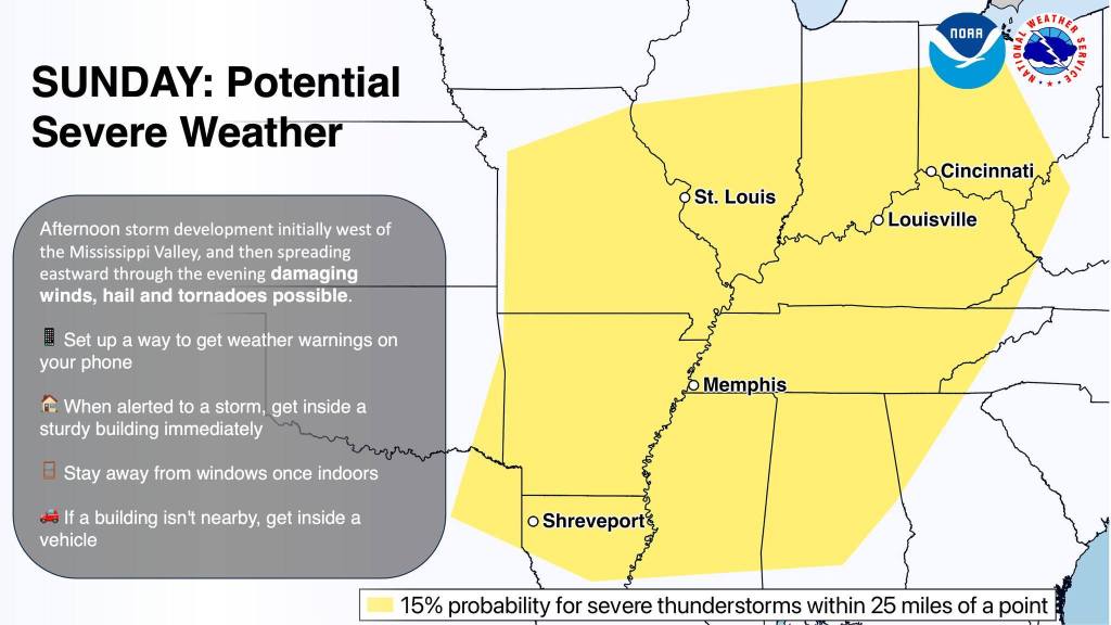
- Graphic from the National Weather Service highlighting the area at risk for severe thunderstorms on Sunday. (Photo sourced from NWS).
|
Getting your Trinity Audio player ready...
|
Jessamine County will likely see rain throughout the weekend, including possible thunderstorms on Sunday and Monday.
On Thursday, the Jessamine County Emergency Management Agency posted an update on Facebook about the weekend’s forecast using National Weather Service (NWS) information. Before that, the agency had warned locals on its Facebook page about the growing possibility of severe thunderstorms.
“Just be ready for severe [weather later] this weekend and, as always, stay aware and prepare,” reads the Emergency Management Agency post.
The report on Thursday showed confidence is increasing for severe thunderstorms Sunday and Sunday night. Confidence in severe potential is currently medium. It stated that all severe hazards are possible during storms, including damaging winds, large hail, and tornados.
The NWS forecast map shows widespread rainfall of 1-2 inches with a swatch of 2-3 inches in Northern Kentucky. Heavy rainfall rates in thunderstorms will increase flash flooding potential, but the NWS said this minor flooding is only likely for the Green River.
As of today, March 28, the forecast from forecast.weather.gov is as follows:
Saturday
A 20 percent chance of showers after 2 p.m. Mostly cloudy, with a high near 76. South wind 9 to 16 mph, with gusts as high as 26 mph.
Saturday Night
Showers are likely, mainly after 2 a.m. It will be mostly cloudy, with a low around 61. The south wind will be 7 to 10 mph. The chance of precipitation is 70 percent. New precipitation amounts between a tenth and quarter of an inch are possible.
Sunday
Showers likely, with thunderstorms also possible after 2 p.m. Mostly cloudy, with a high near 73. South wind 13 to 16 mph, with gusts as high as 25 mph. Chance of precipitation is 70%. New rainfall amounts between a tenth and quarter of an inch, except higher amounts possible in thunderstorms.
Sunday Night
Showers and possibly a thunderstorm. Low around 56. The chance of precipitation is 100%. New rainfall amounts between a half and three-quarters of an inch possible.
Monday
Showers and possibly a thunderstorm, mainly before 2 p.m., then a slight chance of showers and thunderstorms after 2 p.m. The high will be near 61. The chance of precipitation is 80 percent.
Monday Night
A 10 percent chance of showers and thunderstorms before 8 p.m. Mostly cloudy, with a low around 36.
The NWS posted an informative graphic about the five ways to get weather warnings. Those include outdoor sirens, local TV and radio, a battery-powered NOAA weather radio, wireless alerts to your phone, and the internet and apps, including weather.gov, local news, social media, weather apps, and third-party weather sites.


