Possible Kentucky River flooding forecast in Jessamine Co.
Published 2:29 pm Friday, February 14, 2025

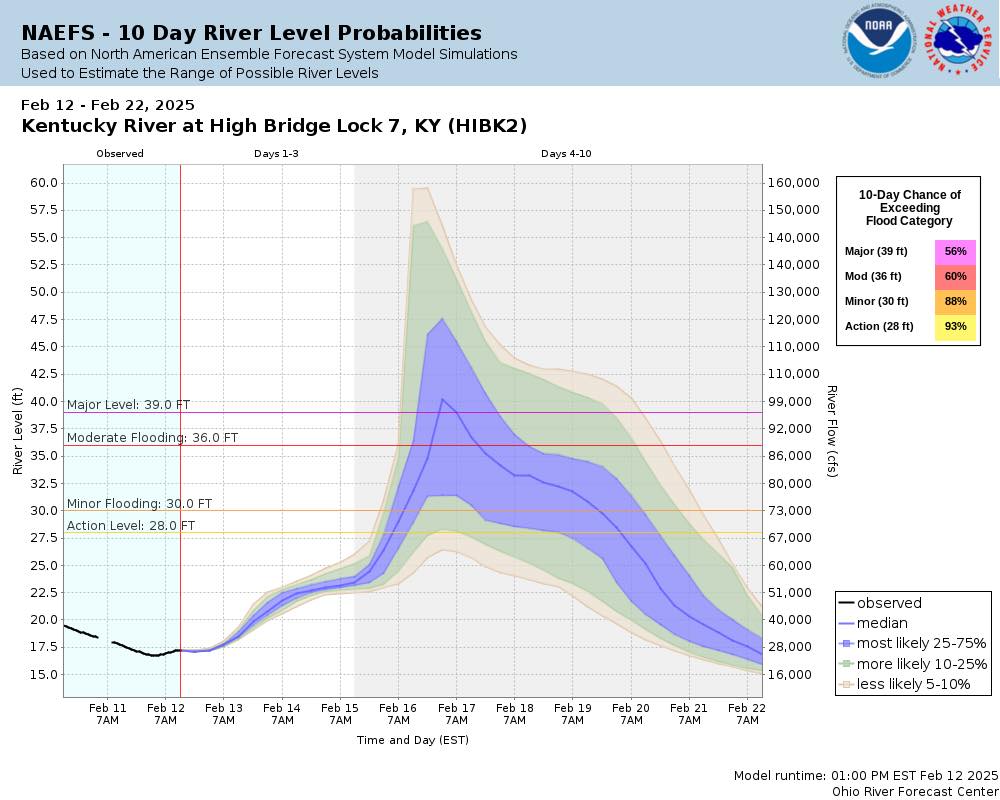
- Ten-day river level probabilities for Kentucky River at High Bridge. (Photo Sourced from Jessamine County Emergency Management Agency)
|
Getting your Trinity Audio player ready...
|
Heavy rainfall is expected this weekend after some wintry weather early this week. Residents living near the Kentucky River and low areas near streams throughout the county should be prepared for flooding this weekend.
The Jessamine County Emergency Management Agency (EMA) posted a photo of the National Weather Service’s (NWS) 10-day river level probabilities for High Bridge and Camp Nelson on Facebook. This chart forecasts that flooding is likely for these areas starting on Saturday, Feb. 15, with river levels continuing to rise through Sunday, Feb. 16.
“Models predict that if we sustain heavy rains Saturday and Sunday, levels will swiftly rise. This may not leave much time to prepare. We will be out in the area and will update you as we see it,” reads a Facebook post by the Jessamine County EMA.
According to the Louisville NWS, there will be heavy rain throughout the state, with 3 to 4 inches forecasted for the Jessamine County area.
Waterdata.usgs.gov monitors river levels in High Bridge and starting at 2 a.m. on Thursday, Feb. 13, river levels increased, making it to about 20 feet by 4:15 p.m. “Minor Flooding” starts for both areas at 30 feet. “Moderate flooding” starts at 36 feet.
Friday, February 14 was mostly sunny in the beginning of the day, so although Kentucky River water levels slightly rose this morning, levels have dropped by 1:30 p.m. back to about 20 feet.
Louisville’s National Weather Service also predicts low temperatures Sunday night that could cause slick roads on Monday morning.


